The story of the English writer John R.R. Tolkien's The Hobbit, or There and Back Again was first published in 1937; in 1954-1955 a sequel was released - the Lord of the Rings trilogy. The action of all these works takes place in Middle-earth (literally Middle Earth) - in Tolkien’s fictional world, which, however, has many parallels with the real world. The author himself prepared several maps of Middle-earth; The rectangular area covers approximately 7 million square meters. kilometers excluding seas. And although Ireland claims that it was its landscapes that inspired Tolkien to create the book, and the popular modern film directed by Peter Jackson was filmed in New Zealand, researchers compare the world of one of the parts of Middle-earth, The Shire, primarily with Great Britain. The setting of The Hobbit, the Shire on Tolkien’s maps, is located approximately in the same place as Britain on modern maps of Europe, and according to the description of everyday life, it is an example of the ideology of “carefree England.” Throughout the story, Tolkien distributed many points of contact with Foggy Albion: from the weather to the dialect of the language. But, nevertheless, the Middle Earth is still a fictional world. And in the interval between the release of the next film in the Hobbit film trilogy, Google created an interactive online map of Middle-earth. The project is called “Journey through Middle-earth” and was carried out as part of the Chrome Experiment. The map is also available on smartphones, tablets and other devices that support Chrome/WebGL. The main language is English, but versions are presented in all major languages, including Russian. By changing the scale and moving around the map, you can refresh your memory of the episodes already shown in the film The Hobbit: An Unexpected Journey. A fairly detailed map allows you to see landscapes and architectural structures, and the soundtrack is the soundtrack of the film and the bewitching voice of the wizard Gandalf. There are currently only three locations available for interactive travel and 3D games based on the film: Troll Highlands, Rivendell and Dol Guldor. Interactive content will soon be added to the following three locations: Thranduil's Hall, Esgaroth and Erebor. This will be timed to coincide with the world premiere of the second series of the film trilogy - The Hobbit: The Desolation of Smaug, scheduled for December 2, 2013. In our country, the film is expected to be released on December 19, so Russian fans of the world of the hobbits will, apparently, be able to walk around a virtual map of Middle-earth before the next part of the epic appears on the screens.
Tolkien's Middle-earth is a special world that has long gone beyond the boundaries of books and films. For millions of fans, this universe has become an integral part of life. They collect paraphernalia from the Lord of the Rings, find where to buy the Ring of Omnipotence, a map of Middle-earth, or the elven pendant of Arwen. Some people sew or purchase full-fledged costumes of the heroes of “The Lord of the Rings” and “The Hobbit”, creating fascinating cosplays, while others prefer to collect miniature figurines of gnomes, hobbits and other inhabitants of Tolkien’s Universe. And in this review we will tell Tolkienists and everyone interested what attributes, toys, souvenirs or unique paintings they could add to their fairy-tale collections if they went to Aliexpress.
And we will begin our review with the thing that has the highest value. I immediately remember the creaky whisper uttered by Gollum in the darkness of the Misty Mountains: “My Prelessness...”. Who among the fans of the epic “The Lord of the Rings” did not want to have that same – most powerful – One Ring? And at the moment, everyone can fulfill such a desire, and there are options for every taste and budget.
Those who want to buy the Ring of Omnipotence - the main ring from The Lord of the Rings - on Aliexpress in the most correct form, as close as possible to the original, can pay attention to this option: 
You can buy the Omnipotence Ring with full engraving, made in “gold” in the WhaleWaves Store:
If you need a more affordable option in gold, then you can choose this ring: 
The Elven inscription on this Ring of Omnipotence on Aliexpress is not engraved, but placed on top - this is the main difference. But probably some of you will want to buy it.
If you want additional magic, special magic contained in the most powerful ring, then you should not miss this copy (oh, and what the Chinese can’t come up with :)

Although this ring does not exactly correspond to the original, it has an obvious “magic” bonus - the mystical glow of the elven inscription in the dark, which attracts all attention. If you suddenly decide to collect a collection of magical attributes of Middle-earth, buying this ring from “The Lord of the Rings” makes sense, if only for the sake of “being” :)
And one more - elegant and sophisticated - version of the Single Ring, for those who were not pleased with either the golden or luminous option. On Aliexpress you can buy a white ceramic Ring of Omnipotence, which will look incredibly elegant on the hand of its lovely owner:

Although it is possible that among men there will be those who want to own “This Charm”, Chinese sellers do not indicate in the advertisement that this jewelry is intended only for a female audience.
But not only the ring of Sauron played an important role in The Lord of the Rings and The Hobbit. The rest of the heroes of the epic also had attributes that had special power and meaning.
Let's remember the King of Mirkwood Thranduil - his fingers were also decorated with magic rings.

As you can see, the Chinese craftsmen did not sit idly by and, like skilled elf craftsmen, forged the entire set. And now what the mighty Thranduil wore can be bought on Aliexpress no more difficult than anything else.
Speaking about elves, one cannot fail to mention the beautiful Arwen - the “Evening Star” - an elven princess of indescribable beauty. Her love for Aragorn is a very significant romantic line of the entire epic, and the scene of handing over Arwen's pendant to Aragorn - "Light of the Evening Star" - became an equally significant and dramatic episode in the film trilogy.
Now you have the opportunity to buy a silver Arwen pendant - this symbol of love and devotion:

Truly, Aliexpress has, perhaps, everything!
By the way, Aragorn himself had “something” that had special power and emphasized the difficult origin of the “Wanderer”. The Ring of Barahir - a symbol of belonging to the family of Isildur and his ancestors, a symbol of royal blood - can be seen on the hand of Aragorn in the films "The Lord of the Rings". And here’s how Aragorn’s ring is presented on Aliexpress: 
Now anyone who is willing to pay 78 rubles for it can afford to wear the symbol of Numenor and the leaders of the North :)
Well, if you love hobbits with all your heart, then try to remember what Frodo used to secure his cloak. Yes, yes, we will talk about Lorien - the Elven leaf, which the brave halfling did not part with throughout his entire campaign:

This brooch-pendant is sold in many Russian online stores at fabulous prices: 900, 1000, 1200 rubles! It is clear that you have to pay for magic, especially elven magic, but not as much :) You, as sensible and practical fans of Middle-earth, can now purchase Lórien at a much lower price:
Well, what should those who “root” for the Dark Side of Tolkien’s Universe do? What accessories can Aliexpress offer? In fact, there are plenty to choose from. For example, a fan of Sauron can purchase this pendant from The Lord of the Rings: 
Yes, neither in the films nor in the books did any of the heroes have such decoration, but is that the main thing? But this pendant is very bright, and the image it contains is definitely familiar to everyone who has even briefly heard about “The Lord of the Rings.”
Well, those who can’t get enough of a pendant with a fiery look may like this T-shirt: 
We don’t know how Sexy this T-shirt with the All-Seeing Eye is (as stated in the ad), but there is no doubt that it looks very impressive. If the Eye of Sauron sees everyone, then the owner of such a T-shirt will, on the contrary, see and notice everyone!
Since we've moved on to items of clothing, let's find out for which heroes of the Middle-earth Universe craftsmen from the Celestial Empire sewed outfits indistinguishable from the original. In fact, there are a lot of costumes from The Lord of the Rings in the online store in question, with a wide range of prices and quality of execution. Let us give an example of those garments that seemed to us the most well made.
And the first costume from the Lord of the Rings universe that we will look at will be Arwen's dress: 
You can buy Princess Arwen's dress from Twinkle Twinkle Star for a pretty reasonable price considering how good it looks.
Are there those among you who consider the most interesting character to be the old magician, Gandalf the Grey? The costume of this Lord of the Rings hero was also found in the vastness of Ali: 
A carefully crafted image - a bright wizard's hat, all the ribbons, folds, belt, etc. Watch the movies again and find 10 differences :)
Well, those who don’t mind going on a dangerous journey in the company of stern dwarves should definitely buy themselves... Yes, of course, a hobbit costume! A frock coat, vest and white shirt, and trousers of the correct length - this is what you should wear on a hike to the Lonely Mountain: 
The hobbit Bilbo costume will, of course, not be so cheap, but your look will definitely be appreciated at any costume party!
But there is one caveat: as you remember, hobbits do not wear shoes, because they do not need them due to the hard skin covered with fur on their feet. Where can you get such “legs”? The answer, as you understand, is below: 
These are the hobbit slippers you can buy just for your own amusement, or to create a full-fledged image of Bilbo, Frodo or one of the other halflings.
You can buy these “hobbit legs”
And, of course, the image of the brave Bilbo and Frodo will be incomplete without the main combat attribute - a sword called “Sting”: 
Bilbo Baggins's sword, of course, will not be an exact copy of the original weapon from the Hobbit trilogy, but the visual similarity, despite being made in plastic, is almost 100% (although it does not glow in the presence of orcs).
But you can give the “Sting” sword to a child and not worry about him getting hurt.
Well, you can buy this sword from The Lord of the Rings here:
So, we have clothes, we have weapons, we can go to Erebor! But everyone knows that the secret door can only be opened on Durin’s Day, and for this you need a special key. So without the key to the mountain there is no point in going on a hike. But masters from China saved Middle-earth fans here too. Here it is - the key to Erebor!

It would seem that we have everything with us, but how can you go on a long journey without a guidebook? Without a Map of Middle-earth, a dangerous journey may not take place. What to do in this case? Of course, you need to buy this very Map of Middle-earth.
We liked these 2 options on Aliexpress.
— map of Middle-earth “in color”: 
— original “retro map” of Tolkien’s world:

You can choose the one you like best. The indicated price range depends on the type of paper on which the card will be made, as well as on its size.
You need to take a notebook with you on the road, in which you can write down all the impressions of what you saw, note the beauty of Rivendell, outline the dangers of traveling in the Misty Mountains, and capture with a shudder your meeting with Gollum.

One more irreplaceable thing will come in handy on your hike. Those who like to eat 6 times a day (and we are talking, if you remember, about hobbits), also need to drink something all these 6 times. Therefore, of course, you need a mug. We invite you to familiarize yourself with these mugs based on the Lord of the Rings.
For those who want to study the map of Middle-earth in detail and are not ready to miss a minute, a mug with this very map:

Well, someone will want to see the most colorful moments from the film about the One Ring: 
Perhaps we should cool down our wild imagination and stop making up stories about a fairytale journey :) Let's move on to the real world with its no less real inhabitants. What do people usually collect? Some toys, figurines, figurines. Or maybe stickers, paintings and posters. We'll talk about them further.
If you have been actively following all the movie epics, be it “Lord of the Rings” or “The Hobbit,” then you should have a whole stack of movie theater flyers lying around. But flyers are not serious. Another thing is full-fledged posters from The Lord of the Rings - its posters with premiere dates: 
If you don’t think that posters have any artistic value, then you should definitely pay attention to the painting from The Lord of the Rings. We specially found something very impressive for you: 
Of course, not everyone will perceive this picture - “The Sword of the Nazgul” either, but the spirit of Tolkien’s fairy-tale world, its depth, beauty and incredibleness, is conveyed in this work of art in the best possible way. In our opinion, of course.
Collectors must really enjoy collecting unique and interesting figurines of epic heroes. In the “depths” of the online store, we managed to find the most secretive creature, who guarded the One Ring for so many years until “They stole it from us!” Gollem, in all his unique emotions, can become a decoration for any figurine collector: 
If your collection needs a more “live” exhibit - a full-fledged toy, parts of which can be moved and fixed in different positions, then Chinese manufacturers have such a Gollum:

A smaller copy with a variety of emotions - both the evil Gollum and the humble Sméagol are clearly visible here. This toy has been worked out to the smallest detail - even the sparse hair matches the original. For the money that is required for such a toy, this is taken for granted.
The figurines of the hobbit Bilbo with his team of dwarves also have the same movable properties: 
These Hobbit minifigures can be purchased from the link below:
There are still 3 things left that most likely will not attract collectors, but could easily appeal to fans of the Middle-earth universe.
Do you remember the majestic statues of the ancient kings that the Fellowship of the Ring met on its way? The Pillars of Argonath can now appear in your home, serving as an excellent themed stand for your book or film collection: 
You can never part with your favorite characters, even when you fall asleep in your own bed :) And we don't mean sleeping with a book in your hands. Now you can purchase themed bed linen, and specifically pillowcases with very interesting prints based on “The Lord of the Rings”:

Decorate your pillows with such “robes”, and Tolkien’s fairy-tale world will become even more real :)
Well, the last thing that did not fit into the selection of carnival costumes for the Lord of the Rings heroes, since it is not a carnival costume. But it's just a really cool thing obliged to be in the wardrobe of girls who are fans of the Tolkien universe! A very impressive dress with an image of a map of Middle-earth. 
It will definitely be difficult for the owner of SUCH a dress to meet anyone wearing the same one :-).
Hurry to breathe a sigh of relief (or maybe disappointment), friends. You have reached your Orodruin and your journey through this overview is complete. We hope you liked it, and you found something useful and interesting for yourself. We wish you never to part with a fairy tale - after all, there must be something magical in our lives! Visit the site again, we will definitely prepare something more interesting for you. Well, if you already know what you would like to read, learn about, or find on the Internet, write about it in the comments! All the best, see you again.
Article Where to buy the One Ring, a map of Middle-earth and Bilbo's sword. Tolkien's World on Aliexpress was modified: November 20, 2019 by Netobserver
It fits on an A4 sheet :)
I drew it in Inkscape, I can send you the source in SVG format upon request if anyone needs it. I am not posting it publicly because it includes scans of several maps, the copyrights of which we do not own.
As a justification, I cite our report at the Small Tolkien Seminar in St. Petersburg on April 23 of this year, with minimal literary corrections and additions based on the results of the discussion at the seminar and after it with Artoron in LiveJournal:
Geography of the South and East of Middle-earth
It all started with natural curiosity. And what is there, further, beyond the edge of the map - in the South and East of Middle-earth? The maps drawn by K. Fonstad are unfortunately disappointing:
Don't you think that the world on this map is too small? The map has a scale. According to measurements, from the pole to the equator there are 5 thousand kilometers, half as much as on Earth. That is, according to Fonstad, Arda is a planet the size of Mars. And this is outright stupidity! It is known that Tolkien identified Arda with Earth. Yes, here on the map, the First Age, Arda is still flat, but when it curled up into a ball, the distance from pole to pole should not have changed.
It is difficult to say what prompted the doctor of geography to do such stupidity. It seems that Fonstad was simply reproducing Tolkien's sketch for Ambarkanta too literally. Here is Tolkien's map:

Scheme V to Ambarkanta
Christopher Tolkien rightly wrote that it is "an extremely careless rough draft, which cannot be interpreted literally." Unfortunately, there are no better cards.
We tried to create such a map. To solve a problem that Fonstad - with all due respect to her - could not cope with (although her atlas is excellent).
The first of our axioms will be the land dimension of Arda. The second axiom is its moderate earth-likeness. The general plan and size of Middle-earth should roughly correspond to the Old World. But the details don't have to be the same.
To imagine the true scale of Tolkien’s West, let’s do this:

This is the true scale of the Lord of the Rings map compared to the world map. We see how small the West is! There, behind the edge of the map, there are a lot of interesting things! How can we expand our horizons? You will need:
understand two sketch maps for Ambarkanta (without cosmology, Aman and Belegaer);
adjust the proportions of the last of the two maps so that the map becomes land-sized;
correct and supplement the data of “Ambarkanta” according to later texts;
draw the final map using your imagination, but in the most important moments be guided not by your imagination, but only by texts and logic;
with some caution, one can also use data from natural sciences, as well as historical maps.
Let us clarify the last point:

We see the famous map of Abraham Ortelius. It reflected Renaissance ideas about the “Great Southern Land”. But “Southland” (almost the same!) is also in Tolkien’s sketch for “Ambarkanta”. So the Professor was inspired not only by modern, but also by ancient maps.
Ambarkanta was created in the second half of the 30s (Númenor - mentioned) and influenced some passages of the Quenta Silmarillion. We must not forget, however, that this is quite early work. We need to look at the last two sketches for Ambarkanta (fourth and fifth).

Scheme IV for Ambarkanta
According to Ambarkanta, Southland and Middle-earth were formerly a single supercontinent. After the overthrow of the Pillars, two inland seas appeared - Helkar (Sea of Helkar) and Ringil (Sea of Ringil) - and three parts of land: Northern Lands, Northland (north of Helkar), Middle Lands, Mid-land (between the seas) and Southern Land, South-land (south of Ringil). The Valar pushed the continent to the east, and Middle-earth bent into an arc. Due to the movement of the continent, four mountain ranges arose closer to its edges: Blue Mountains in the northwest, Red Mountains in the northeast, Gray Mountains in the southwest and Yellow Mountains. in the southeast. In the eastern equatorial region, the “Mountains of the Wind” are also shown. The Iron Mountains, Utumna, Beleriand, Falassë, Helkaraksë and similar straits in other parts of the world are also named, Kuivi énen and the route of the Long March are shown. Elves). The concept of mountain building in connection with the movement of continents echoes the modern theory of plate tectonics (although the details do not agree). Under Tolkien, this opinion was already voiced, but until the 60s it was considered a “geological heresy.” The idea of continental movement was still quite extravagant. But whether Tolkien knew about Wegener’s theory is not known for certain.
It must be said that the symmetry and schematism of this map somewhat undermine our confidence in it, because they contradict a more authoritative later text. According to Ainulindal, the symmetry of the lands was broken long before the assault on Utumno and even, probably, before the overthrow of the Pillars.
The conventionality of the schematic map is emphasized by the appearance of Hildorien on it. According to Ambarkanta, the single supercontinent was divided even before people awakened. And here, on the map, everything is synchronous. Hildorien - in full agreement with the early texts - is shown in the equatorial region, near the Eastern Sea. Judging by the map, this is an entire country comparable in size to Beleriand.
The most mysterious object on the map is Endon. Endon is mentioned in later texts, up to the Transfigured Myths (MR: 72, 377), and appears as the central region or even the central point (point) of Middle-earth. To talk more about Endon, we need the following map (see Fig. 2 above).
Orome rode through Endon, turned north to the inland sea of Helkar - and found the elves there. Endon lies not only south of Helkar, but it doesn’t seem to be very far away. If Helkar turned out to be, say, the Caspian Sea, then we would have to place the “Center of Middle-earth” in the Middle East (where medieval geographers drew the center of the world). And not in Africa, for example. It is doubtful that any of the Eldar had been to Endon, but Orome knew about this place and could tell the Elves. Why is this mysterious “point” so important to the Vala? Let us make a hypothesis: in the central part of the world, on a great lake, there once lay the island of Almaren, where the first dwellings of the Valar were located. No matter how this place changes, the Valar must recognize it and declare it the central point of Middle-earth.
By the way, what happened to the Great Lake when the Lamps collapsed? Let's pay attention to the shape and size of the sea of Illuin! It occupies both the southern and equatorial regions of the world. We can conclude that the lake (or at least part of it) did not disappear anywhere, but merged with the reservoir at the site of the southern pillar. But in this case, the island of Almaren could turn into a peninsula on the shores of the southern sea. For example, the peninsula in Figure 2, which looks suspiciously like Arabia.
In this map, Middle-earth bears a curious resemblance to Earth. You can find here not only Arabia, but even the Red Sea, the “African” contour of Harad, and the peninsula in the east looks like either India or Indochina. In place of the mythical Southern Earth from maps of the Renaissance period, Antarctica, Australia, and New Guinea lie in earthly reality. We see in Ambarkant two names for this continent: both Dark Land and Southland (Dark Land, Southland). What does the first name mean? According to Akallabeth, the ships of the Númenóreans sailed “from the northern darkness to the southern heat and further south into the lower darkness” - we are probably talking about the Antarctic polar night.
About the Land of the Sun, according to Ambarkanta, “little is known.” Along the coast stretched the Walls of the Sun, a chain of mountains similar to Pelori, but a little lower. In the mountains is the Gate of Morning, from where the sun rose. The Gate of Morning was observed by Númenórean sailors. If we accept the theory about the “originally round Arda,” which before Akallabeth should have included Aman, we can come to the following guess: the Numenoreans sailed to Aman from the other, western side - but the mountains did not allow them to get into Valinor. True, when composing Ambarkanta, Tolkien could not have had such an idea. The legend on the map reads: “Burnt Land of the Sun”. That is, the resting Sun, according to Ambarkanta, should turn the area east of the mountains into a desert. Therefore, there was hardly anything interesting in this “anti-Valinor”.
Let's return to Middle-earth! Here a new detail arose - the mountain range in Haradh. Christopher wonders why the Gray Mountains are north of the equator when they should be south. But who said that these are the “Grey Mountains”? Middle-earth is large, there are not four or five mountain ranges. Perhaps the Haradian Mountains were even interpreted as a continuation of the Blue and White Mountains. According to Ambarkanta, in the First Age the White Mountains were a continuation of the Blue Mountains. Later, Tolkien most likely abandoned this concept, but for the 30s it was relevant and was reflected in the geographical passage “The Quanta Silmarillion” (QS: 108). Moreover, according to this passage, the Sea of Helcar came very close to the southern bay of Belegaer, and the two were separated only by "a mountainous bridge by which one could penetrate into vast regions in the South of Middle-earth." On the map to Ambarkanta, this “bridge” is called “The Straits of the World” and corresponds to the area of Minas Tirith and the Mordor Mountains. The Mordor plateau is flooded with the waters of Helkar. The Mordor Mountains are not shown (this does not mean that there were no mountains in the First Age - the Misty Mountains are also not indicated in this “quick sketch”). Helkar stretched from Mordor to Orocarni - but, in our opinion, such an extent does not agree well with later texts. Indeed, in the Ambarkanta paradigm, the Sea of Runes cannot but be interpreted as a surviving part of the dried-up Helkar. However, according to later texts, the Sea of Rhun even in the First Age was a separate body of water, on the shores of which the ancestors of the Edain stopped (PM :373), and even earlier - the elves of the Great March (PM :387). But if Rune and Helkar in later texts are different seas, then Helkar could not be as huge as shown on the map to Ambarkanta. However, in this case, we get a striking disproportion between the pair of seas in place of the two Pillars: compare the dimensions of the Caspian Sea with the Indian Ocean.
But let's pay attention to another point! The Helkar on the map for Ambarkanta bears a striking resemblance to the historical Sarmatian Sea:

About 7-9 million years ago, the Sarmatian Sea stretched from Central Asia to the Adriatic. Its remains are the Black, Caspian, Azov Seas, as well as the Hungarian Plain with Lake Balaton. Tolkien might have known about this body of water: marine sediments on the site of the Sarmatian Sea have been studied since the end of the 19th century.
It seems that the map to Ambarkanta could reflect a prehistoric situation. By the end of geological eras, Paleohelkar, like the Sarmatian Sea, could have partially dried up. In its place, as on Earth, several bodies of water could remain. In the extreme west are Nurnen and Run, and in the east is Helkar itself, near Kuivianen.
Now it is time to turn to our map with the reconstruction of the East and South of Middle-earth - as of the beginning of the Third Age.
The main difficulty we had to face was that it was not so easy to correctly link the known map of the Western lands of Middle-earth to the map of Earth. We only know that Hobbiton was approximately in the latitude of Oxford, and Minas Tirith in the latitude of Florence; This is not enough for accurate binding. In addition, as Fonstad noted, the map of the Western Lands is actually drawn up as a map of a flat world. There is no coordinate grid, but there is a north indicator, as if north were simply at the top, without any clarification, and the distances are not distorted, which is impossible in any map projection. It is unlikely that these circumstances should be considered as insurmountable: after all, it was important for Tolkien to maintain a certain style, within the framework of which such details as a map projection and a coordinate grid are simply unacceptable. But even with this caveat in mind, in order to combine the maps of Middle-earth and Europe with any plausibility, non-trivial calculations are required, for which you need to write your own computer program, since existing geographic information systems simply do not provide such capabilities. At the moment, the most correct calculation seems to be Brandon Rhodes (http://rhodesmill.org/brandon/2009/google-earth-and-middle-earth/):

But his method of calculation also raises doubts, since in this case the northern part of Middle-earth turns out to be somewhat stretched compared to the original map.
At the same time, our task is made easier by the fact that we are primarily interested in the East and South of Middle-earth, for which there are no accurate maps, so we can certainly discuss their geography only in the most general approximation. Therefore, to solve this particular problem, we considered it sufficient to simply superimpose the map of the Western Lands onto the world map, slightly adjusting its proportions taking into account Rhodes’ calculations, and then draw the contours of the rest of Middle-earth in a regular graphics editor. We used a world map in polyconic projection as our basis, mainly because it places the Old World in the center, so that the contours of Europe, Asia and Africa are subject to only minimal distortion. The West of Middle-earth on such a map will look something like this:
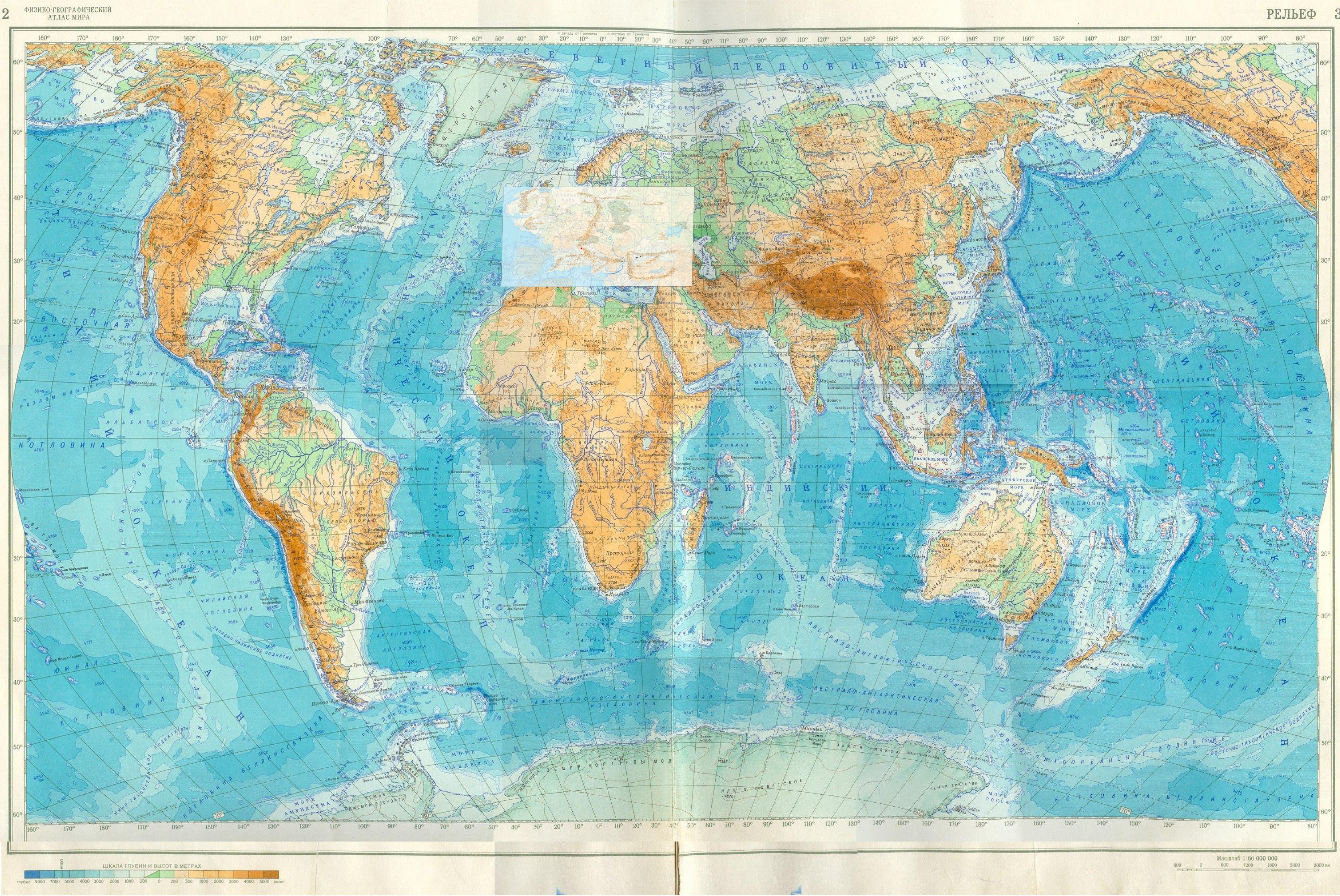
We took diagram V from Ambarkanta as the basis for our own map of the East and South; fortunately, Harad on it clearly resembles Africa in its outline, which makes it easier to reference. If you superimpose this diagram on a world map, stretching it to the required size, but at the same time keeping the Western Lands at the correct scale, you get the following picture:

We haven’t been fantasizing here for a minute, we’ve just acted according to the established algorithm. The two “red arms” are objects with a controversial status: bays that Tolkien sketched very vaguely on the map for “Ambarkanta” (either they are there, or they are not). These bays are very similar to the Red Sea and the Persian Gulf.
However, there is one problem. Arda, of course, is land-scale, but the continents themselves in their proportions are now not very similar to either the map for “Ambarkanta” or to the Earth. And in any case, the map that we received mechanically must be processed creatively.

The most important and inevitable fix is this: we have "flooded" the northwestern part of Harad to bring it into line with the Lord of the Rings map. This region may have been flooded at the end of the First Age when Beleriand died.
If you remove the world map and add a grid frame, you get the map of Middle-earth shown at the beginning of this post (it's different from the map we showed during the talk). Let's talk about this card in more detail.
We see four mountain systems "Ambarkanta" - Blue, Yellow, Southern Gray and Red Mountains (or Orocarni). The Blue Mountains appear to be the smallest, as a huge part of them was destroyed at the end of the First Age. We drew the red mountains so that on one side they were close to the ocean, on the other - to Kuivianen, which is difficult to move too far to the east. The Wind Mountains are shown according to Ambarkanta: only this mountain system was depicted as several parallel ridges. We decided that this was an exceptionally wide highland, comparable in area to Tibet. Southern mountain systems, like northern ones, should also be located at high latitudes. The Yellow Mountains roughly correspond to the Great Dividing Range in Australia. The position of the Southern Gray Mountains is not entirely clear: in these latitudes there should be a strait between the Dark Land and the extreme south of Middle-earth. We depicted these mountains on both continents. In this case, mountainous islands may appear in the strait. On our map, Southern Earth split into two parts. This strait is a figment of our imagination, but the fantasy in this case is not entirely groundless: it is known that the death of Numenor was accompanied by destruction in the rest of the world. It seems to us that with the passage of epochs the world is becoming more earth-like. Therefore, it was logical to separate “Australia” and “Antarctica” by a sea strait and coincide its occurrence with the events of Akallabet.
We showed the equatorial forest in the central part of Harad: in The Lord of the Rings “apes in the dark forests of the South” are mentioned (LotR, 2, III, ch. 7). In the coastal part of Harad there are mountains. But nothing is known about other objects.
It is necessary to give only a few general considerations. If for us the north of Africa is a desert, and the south is a separate world, hopelessly lagging behind Asia, then in Middle-earth the role of Harad seems much more serious to us. The South is probably not inferior to the East either in resources or in level of civilization. Near Harad is a fertile and densely populated land, although all this population caused a lot of trouble for the people of the West. And if the colonial powers divided Africa at the very least, the South of Middle-earth became the main object of Númenórean expansion and plunder.
There may be islands in the seas that we did not depict.
More is known about the East of the continent. Let us stipulate once again that the details of our map are a figment of the imagination, but all its essential elements follow from the texts, directly or indirectly.
The bottom of the dry “Paleohelkar” should become a huge lowland. Judging by its geographical position, the plain should coincide with the steppe belt, from where the Vastaki nomads moved to the West. Previously, both the Eldar and the Edain probably walked to the West along these same plains. Several relict lakes-sea remain here. The largest and easternmost of them is Helkar itself, the main relic of the “Paleohelkar”. The Waters of the Awakening were located on its eastern shores, but in later eras Kuivianen no longer existed. East of Helkar, in the foothills of Orocarni, is the region of the “Wild Wood”, these forests are mentioned in “The Lord of the Rings” (LotR, 2, III, ch. 3). Based on Ambarkanta, the Orocarni must be closer to the Eastern Ocean than the Western Ocean. However, it is far from the Ocean. The Utumno fortress is located more north of Kuivianen than to the west - during the War of Powers, it is in the north that the elves see the glow (Silm). Based on all these considerations, we place Helkar with Kuivianen approximately at the longitude of Altai. But in terms of latitude, these places, judging by the maps for Ambarkanta, are somewhat further south.
It is known that before crossing the Anduin the elves had not seen a river of comparable size. They didn't have to cross mountain ranges like the Misty Mountains either. The Anduin is not such a great river; in its middle reaches it is as wide as a shot from Legolas's bow. The Anduin is comparable in length to the Danube. This means that on the way through the plains the elves did not encounter any major rivers like the Volga and Dnieper. Therefore, it should be assumed that immediately to the north of the “Paleohelkar” lowlands there lies a watershed. It may turn out to be a continuation of the belt of the Gray Mountains and Iron Hills and should probably already lie in the forest belt, north of the steppes. The fact that there are indeed mountain systems in this area is evidenced by the geography of the Dwarven peoples. As we know, the Dwarves awoke in four different places: the north of the Blue Mountains, Mount Gundabad, and two eastern regions unknown to the Elves and Western Men (PM :301). Where there are gnomes, there are mountains! The two dwarven regions lay far from each other and from the possessions of their western relatives. But, despite the distances, all the dwarves kept in touch. Had they lived further south, this connection would most likely have been interrupted by the savage Vastaks who filled the steppe. It is logical that the gnome lives in the mountains, and not at the bottom of the former sea. But far to the north, in the tundra belt, it is also difficult for gnomes to live permanently: they will survive the cold, but what to eat?
The rivers in the north of Middle-earth should (due to the watershed) flow from south to north, as in Siberia. They flow into the ocean, assuming that Arda has an analogue to the Arctic Ocean. If the land extends to the pole, then there should be glaciers, and to the south of them there should be periglacial lakes (as on Earth during the Ice Age). This is where rivers could flow. The third, and in our opinion, the least likely option is the presence of some kind of “super river”, longer than the Nile, deeper than the Amazon. This river can flow from west to east across the entire Ardian "Siberia" and flow into the eastern sea. If this stream had flowed to the West, to Forodwaith, it would probably have ended up on the maps, and Anduin would have lost the title of “Great River”. In the far north, near the sea or eternal ice, there should be the remains of the Iron Mountains, badly destroyed after the War of Powers. We draw them as a broken chain. What could be south of Helkar and the great plains? The existence of large mountain ranges here is also unlikely. Climatology leads us to this conclusion: beech trees (Hobbit) grew in Greenwood, that is, the climate east of the Misty Mountains was not sharply continental. Where does the moisture and rain come from here? In the West are the Misty and Blue Mountains. In the north are the Gray Mountains and probably the remains of the Iron Mountains; and in any case, it is unlikely that the Arctic wind could significantly moderate the climate. Directly to the east are the monstrous continental masses and the Orocarni ridge. The only possible direction, in our opinion, is from the southeast and south. Moisture and life should be brought to the central regions of Middle-earth by powerful winds from the southern ocean. This means that there are no large mountains in the path of these winds. Otherwise, Rhovanion and Rhun would turn into deserts (the sea of Rhun is small and will not make any difference to the weather). South of Helkar may have been the site of the people's awakening. The professor refused to localize Hildorien in the extreme east, beyond the Wind Mountains: according to the new version, Hildorien (WJ:173) lay in the central regions of Middle-earth, “beyond the inland sea,” in lands unknown to the elves. This could not be either the extreme East or the outskirts of Kuivianen. It seems to us that these “central regions of Middle-earth” may lie somewhere in tropical latitudes and correspond to our India or Iran.
Update: Hildorien has been found!
After the April workshop, we managed to approximately localize Hildorien and even restore some geographical details. It's all thanks to observation tar_elentirmo - a detail that has escaped both our attention and, as far as we know, the attention of all cartographers.
In his second note to “The sinking of Anadune” (“The theory of this version,” “Sketch II”) Tolkien writes:
Men ‘awoke’ first in the midst of the Great Middle Earth (Europe and Asia), and Asia was first thinly inhabited, before the Dark Ages of great cold. Even before that time Men had spread westward (and eastward) as far as the shores of the Sea.
(SD:398)
So, we are talking about some area approximately in the center of Middle-earth, far from both the Western and the Eastern Sea.
The Great Central Land, Europe and Asia, was first inhabited. Men awoke in Mesopotamia. Their fates as they spread were very various.
(SD:410)
So, in this note, the place of people’s awakening is Mesopotamia, that is, Mesopotamia (the area between two major rivers). Is it possible to compare this area with our Mesopotamia? Probably yes. As has already been shown above, on the original Tolkien map for “Ambarkanta” both the “Red Sea” and the “Persian Gulf” are clearly visible. The territory north of the “Persian Gulf” is indeed almost equally distant from the Eastern and Western Oceans (which corresponds to “Sketch II”) and, by the way, is located not far from the mysterious Endon. This area fits well with another indication (WJ:173): Hildórien lay in the central regions of Middle-earth, “beyond the inland sea,” in lands unknown to the elves.
In a fairly close area (“Iran”) we showed Hildorien earlier, now we managed to clarify its location and at the same time add new geographical objects.
To depict "Mesopotamia", we need the "Tigris" and "Euphrates" - large rivers flowing from north to south. If we are talking about two large rivers in such latitudes, their sources should be in a mountainous region, on a certain “Armenian Highlands”. However, the mountains in this area should not be too high and extensive (for climatological reasons, see above).
In addition, the objects of Middle-earth must be not too similar to our Earth. Therefore, the sources of the Tigris and Euphrates on our map are shown not to the northwest of their mouth, but strictly to the north or north-northeast.
"Mesopotamia" must be a vast country. Is it possible to clarify the position of Hildorien? We assume that it lies in the far north of Mesopotamia, in the foothills, not far from the source of two rivers. Firstly, we cannot discount biblical allusions: according to the Book of Genesis, four great rivers flowed from Eden, and two of them were the Tigris and Euphrates (we remember that the fall of people took place in Hildorien). Secondly, the remoteness and inaccessibility of this territory fits well with the requirements of WJ:173: the mountainous region is indeed more likely than all others to become an “unknown country” for the elves. Thirdly, in the only place where the landscape of Hildorien is described (The Book of Lost Tales) we are talking specifically about a mountain valley. In other words, for younger children, history begins not in “Sumer”, but somewhere in “Urartu”.