Is your phone being tapped?
To do this you will need:
1.Mobile phone;
2.Internet access;
The phone must support netmonitor. Don’t be alarmed, this built-in utility is present in almost every second mobile phone, as well as in all phones with Android and iOS.
IPhone is *3001#12345#*,
Android *#*#4636#*#* or *#*#197328640#*#*.
In my example, iPhone 4s.
Open netmonitor by dialing *3001#12345#*, then the UMTS Cell Environment tab, then UMTS RR info. We are interested in the Cell ID field. On iPhones, this number is represented somewhat differently, or rather in hexadecimal (hex) format, for example 1a123cc.
We monitor this field and write down all the values of the Cell ID field on a piece of paper; there won’t be many of them, most likely less than five.
The phone itself selects a BS (base station) based on the best signal level, location range, etc., so most likely there will be several BS numbers, but still unlikely to be very many. We need to know the identifiers of all base stations that the phone can pick up in this location.
All. Now, in moments of particularly aggravated paranoia, you can come here and check our leaflet for the unknown numbers of the “base stations” that may be located in Gazelle near the entrance)))
I'll move on to the second part of the topic title.
Knowing the identifier of the BS that serves us in this moment, all you need to know is LAC, Local Area Code - local area code.
In order to find out LAC, go to netmonitor, open the MM info tab, then Serving PLMN:
After we have found out the LAC and Cell ID, we go to http://xinit.ru/bs/.

My base station was not found, so I could not determine whether I was being monitored or not.
On this site you can determine the approximate location of the phone, knowing just a few parameters:
MCC (Russia 250, Ukraine 255, Belarus 257)
MNC (network code: Beeline - 99, MTS - 01, Megafon - 02, Tele 2 - 20, Rostelecom - 39)
LAC (how to find out LAC is written above)
CID (how to find out LAC is written above)
In large cities there are rarely problems with signal reception mobile operators, except in the subway or underground passages. But as soon as you go out of town, for example, to a dacha or to the beach, you immediately come face to face with the problem of reception. And you usually spend the most time searching for that very signal.
Application open coverage map will significantly save your time. By tracking the location of cell towers, it can easily show in which direction the nearest station is located.


For this purpose, the application has a special compass, which is located in the review section. It is also available by clicking on the program's compact widget. But this is not the only way to find a signal using open coverage map. In the map section you will immediately see the location of all nearby towers. If there is no mobile Internet, you can use the radar layer.


From other functions open coverage map you can note:
- search for WiFi points (however, during testing it was revealed that it was a little wrong in the direction).
- connection speed measurement
- displaying detailed information about signal strength
- saving WiFi access points and maps of their locations (when running a speed test)
- displaying the history of signal strength measurements
- plotting signal strength
One of the first questions that arises when you are connecting to mobile internet, this is a question about the location of the base station of your chosen operator in order to point your antenna in its direction. It is advisable to find out the exact coordinates of the tower and the terrain before it in order to understand whether it makes sense to use the tower to receive the signal. Services and various Android applications do not provide exact coordinates of the BS, because based on measurements and their mathematical processing. The error can reach several kilometers.
Often, tower coordinates can be determined by studying operator coverage maps, terrain, Google and Yandex maps, as well as the opportunities they provide to view photographs and panoramas of the area being studied. It must be said that the BS cannot always be found on the map. There may be many reasons for this - the maps are outdated, the BS is located on the roof of the building and is simply not visible on the map, the tower has small sizes and so on.
BS parameters are unknown. Kostroma region
Given: coordinates 57.564243, 41.08345, Kuzminka village in the Kostroma region.
The task is to determine the exact coordinates of the BS to which you can connect to receive a 3G signal. We will consider the search for BS step by step.
Step 1. Analysis of coverage maps.
Let's use the well-known service yota-faq.ru/yota-zone-map/, which presents the coverage areas of four operators, except Beeline. I will note here that the Beeline coverage presented on their website is almost impossible to use - as a rule, it shows continuous coverage that does not take into account the terrain. The coverage areas of Megafon and MTS look the most interesting from a connection point of view. You can see this for yourself by opening the service, inserting coordinates into the search bar and switching operators.
Megafon coverage area:
MTS coverage area:

From the analysis of Megafon's coverage area, we see that 3G BS are most likely located in the directions Krasnoye, Sukhonogovo, Lapino (at this scale the Lapino map is not visible, this is the southwest, approximately where the P-600 mark is).
The MTS coverage area is more interesting. Here we also consider the direction to Sukhonogovo and Krasnoe. But Red is a more interesting option, because... there is 4G coverage there. The distance to Krasny is about 10 km, if MTS distributes 4G at a frequency of 1800 MHz, then there is every chance of establishing communication with one of the MTS BSs located in this locality.
Step 2. Study of the terrain.
The terrain up to Krasny is difficult, but quite passable. To assess the terrain, we will use the service https://airlink.ubnt.com. If this is your first time on this site, you will first need to go through a free registration procedure. Having opened the service, scroll the slider down to the end and enter the initial data in the lower right corner, as shown in the following figure.

I usually first enter the same coordinates in both windows, and then start moving the purple mark to the points of interest to me, where the BS could presumably be located. In this case, the top right corner of the screen displays the terrain, the line of sight and the approximate size of the Fresnel zone.
For our coordinates we have:


Checking the terrain in other “suspicious” directions showed that the terrain there is much worse. Thus, we decided on the direction and at the same time chose the operator - MTS.
Step 3. Clarifying our choice using the “Communication Quality” service
The service opens at the following address https://geo.minsvyaz.ru. IN search bar set the name of the village Kuzminka, switch the view from 4 windows to single-window mode, scale the map to a convenient size and get for the MTS operator:

We see that our choice is correct, because according to the measurement database of users of this service, Krasnoye actually has good 4G coverage from MTS.
Let's zoom in on this map and see that the most likely location of the tower (or towers) is Sovetskaya and Okruzhnaya streets.

Step 4. Study the area using Google and Yandex maps.
These maps have a useful tool for studying the area - panoramas and photographs of the area. Google maps have much more panoramas of various areas than Yandex, so you have to use Google more often when looking at panoramas. On the other hand, Yandex has more photos taken in different places, in addition, Yandex maps for Russia are usually more relevant. In this regard, you have to use both services. Google maps and services are used here.
So, we found out that we need to consider two streets in Krasnoye in search of BS. Launch Google maps, enter the approximate coordinates of the street. Sovetskaya (or street name) and we get:

Here the street view mode is turned on, the street we need is highlighted in blue on the map. You can get a panorama of the street by clicking the mouse anywhere on the blue line. Moving in this way along the street to the north, at the post office building we find the first BS:


And finally, not far from the intersection of Sovetskaya and Okruzhnaya streets, a third tower is discovered, the highest of those found:
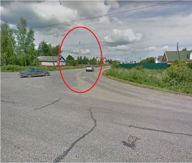
We return to the map and find the shadow of this tower in the place where the photo points:

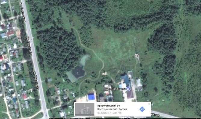
We mark this place on the map with the mouse and get the exact coordinates of the BS:
Let us summarize some of the results of our research. Using information obtained from coverage area analysis, user measurements of signal strength in the area of interest, and study of the area through photographs and panoramas, we were able to find three base stations and their exact coordinates in a city we had never been to. The question of which operator owns the found BS remains open, because the answer to this requires additional research. The easiest way is to drive along the route and measure the BS parameters using some Android application that displays MNC, MCC and signal strength. Some of these applications are presented here.
The parameters of the BS are known. Suburb of Penza
As is known, a number of Android applications, as well as a HiLink modem interface and an MDMA program, can provide BS parameters, with the help of which well-known services and applications can provide approximate BS coordinates, which makes it easier to find specific BS coordinates on maps. Let's look at a specific example from the forum, the example is based on

Distance to the tower is approximately 4800 meters:

As can be seen from our research, the error in determining the BS coordinates obtained using the xinit.ru/bs service is very significant - almost 2 km. Such errors are typical for all services based on user measurement databases, but there are no other services available.
Conclusion
The presented technique, based on the use of widely available cartographic tools, does not always, but quite often allows one to find the exact coordinates of the BS. Significant assistance in determining whether a BS belongs to a particular operator is provided by services that provide information on the parameters of the BS and its approximate coordinates.
To do this you will need:
1.Mobile phone;
2.Internet access;
The phone must support netmonitor. Don’t be alarmed, this built-in utility is present in almost every second mobile phone, as well as in all phones with Android and iOS.
IPhone is *3001#12345#* ,
Android *#*#4636#*#* or *#*#197328640#*#* .
In my example, iPhone 4s.
Open netmonitor by dialing *3001#12345#*, then the UMTS Cell Environment tab, then UMTS RR info. We are interested in the Cell ID field. On iPhones, this number is represented somewhat differently, or rather in hexadecimal (hex) format, for example 1a123cc.
We monitor this field and write down all the values of the Cell ID field on a piece of paper; there won’t be many of them, most likely less than five.
The phone itself selects a BS (base station) based on the best signal level, location range, etc., so most likely there will be several BS numbers, but still unlikely to be very many. We need to know the identifiers of all base stations that the phone can pick up in this location.
All. Now, in moments of particularly aggravated paranoia, you can come here and check our leaflet for the unknown numbers of the “base stations” that may be located in Gazelle near the entrance)))
I'll move on to the second part of the topic title.
Knowing the identifier of the BS that is serving us at the moment, all you need to know is LAC, Local Area Code - local area code.
In order to find out LAC, go to netmonitor, open the MM info tab, then Serving PLMN:
After we have found out the LAC and Cell ID, we go to http://xinit.ru/bs/. 
At the time of writing this post, my base station was not found, so I could not determine whether I was being monitored or not.
On this site http://opencellid.org/ you can determine the approximate location of the phone, knowing just a few parameters:
MCC (Russia 250, Ukraine 255, Belarus 257)
MNC (network code: Beeline - 99, MTS - 01, Megafon - 02, Tele 2 - 20, Rostelecom - 39)
LAC (how to find out LAC is written above)
CID (how to find out LAC is written above)
http://opencellid.org/ fill out the fields (enter Cell ID in hex format in the appropriate field!) and admire the map.

Thus, we can view the location of a mobile phone absolutely free. Convenient isn't it?